ವಿಷಯಕ್ಕೆ ಹೋಗು

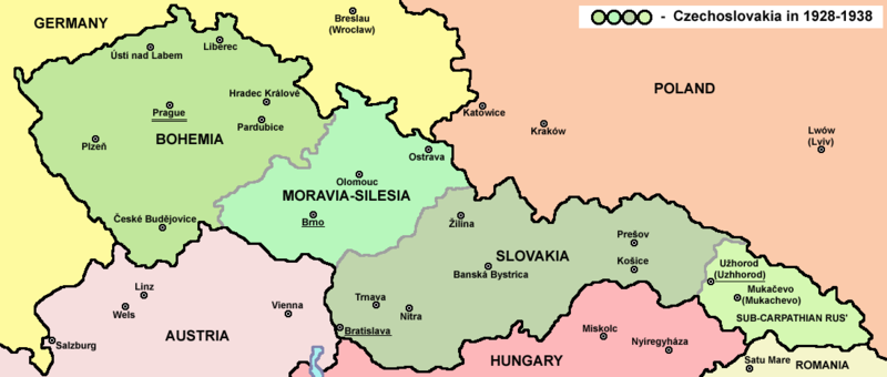
ಚಿತ್ರ:Czechoslovakia01.png

Page contents not supported in other languages.
ವಿಕಿಪೀಡಿಯದಿಂದ, ಇದು ಮುಕ್ತ ಹಾಗೂ ಸ್ವತಂತ್ರ ವಿಶ್ವಕೋಶ

ಮೂಲ ಕಡತ (೧,೧೦೦ × ೪೬೮ ಚಿತ್ರಬಿಂದು, ಫೈಲಿನ ಗಾತ್ರ: ೬೩ KB, MIME ಪ್ರಕಾರ: image/png)

File:First Czechoslovak Republic (1928).svg is a vector version of this file. It should be used in place of this PNG file when not inferior.

File:Czechoslovakia01.png → File:First Czechoslovak Republic (1928).svg

For more information, see Help:SVG.

In other languages
Alemannisch  العربية  беларуская (тарашкевіца)  български  বাংলা  català  нохчийн  čeština  dansk  Deutsch  Ελληνικά  English  British English  Esperanto  español  eesti  euskara  فارسی  suomi  français  Frysk  galego  Alemannisch  עברית  hrvatski  magyar  հայերեն  Bahasa Indonesia  Ido  italiano  日本語  ქართული  한국어  lietuvių  македонски  മലയാളം  Bahasa Melayu  norsk bokmål  Plattdüütsch  Nederlands  norsk nynorsk  norsk  occitan  polski  prūsiskan  português  português do Brasil  română  русский  sicilianu  Scots  slovenčina  slovenščina  српски / srpski  svenska  தமிழ்  ไทย  Türkçe  татарча / tatarça  українська  vèneto  Tiếng Việt  中文  中文(中国大陆)  中文(简体)  中文(繁體)  中文(马来西亚)  中文(新加坡)  中文(臺灣)  中文(臺灣)  +/−
New SVG image

ಸಾರಾಂಶ

ವಿವರ
English: Map of Czechoslovakia in 1928-1938. Note: The provinces shown on the map were introduced by Act No. 125/1927 Zb. and became effective in 1928.
Deutsch: Karte der Tschechoslowakei zwischen 1928 und 1938.
ದಿನಾಂಕ
ಆಕರ

ಸ್ವಂತ ಕೆಲಸ Main reference:

Secondary references with similar maps:

Secondary references about Geo-political situation - published sources:

  • The Times History of Europe, Times Books, London, 2002.
  • Richard Overy, The Times History of the 20th Century, Times Books, London, 2004.
  • The Times Atlas svjetske povijesti, Cankarjeva založba, Ljubljana - Zagreb, 1986.
  • Istorijski atlas, Geokarta, Beograd, 1999.
  • Školski istorijski atlas, Zavod za izdavanje udžbenika SR Srbije, Beograd, 1970.
  • Povijesni atlas, Učila - Zagreb, Zagreb, 1971.
  • Povijesni atlas za osnovnu školu, Kartografija - Tlos, Zagreb, 1975.
  • Denis Šehić - Demir Šehić, Istorijski atlas sveta, Beograd, 2007.

Secondary reference about sizable cities:

ಕರ್ತೃ

PANONIAN

Atlas This map has been uploaded by Electionworld from en.wikipedia.org to enable the Wikimedia Atlas of the World . Original uploader to en.wikipedia.org was PANONIAN, known as PANONIAN at en.wikipedia.org. Electionworld is not the creator of this map. Licensing information is below.
ಅನುಮತಿ
(ಈ ಕಡತವನ್ನು ಮರುಬಳಕೆ ಮಾಡಲಾಗುತ್ತಿದೆ)
Public domain I, the copyright holder of this work, release this work into the public domain. This applies worldwide.
In some countries this may not be legally possible; if so:
I grant anyone the right to use this work for any purpose, without any conditions, unless such conditions are required by law.
ಇತರೆ ಆವೃತ್ತಿಗಳು

Derivative works of this file:


Captions

Add a one-line explanation of what this file represents

Items portrayed in this file

depicts ಇಂಗ್ಲಿಷ್

source of file ಇಂಗ್ಲಿಷ್

original creation by uploader ಇಂಗ್ಲಿಷ್

media type ಇಂಗ್ಲಿಷ್

image/png

checksum ಇಂಗ್ಲಿಷ್

bd003d1960e9404724758c8fa7f85ee852d01738

determination method or standard ಇಂಗ್ಲಿಷ್: SHA-1

data size ಇಂಗ್ಲಿಷ್

೬೪,೦೨೦ byte

height ಇಂಗ್ಲಿಷ್

೪೬೮ pixel

width ಇಂಗ್ಲಿಷ್

೧,೧೦೦ pixel

ಕಡತದ ಇತಿಹಾಸ

ದಿನ/ಕಾಲ ಒತ್ತಿದರೆ ಆ ಸಮಯದಲ್ಲಿ ಈ ಕಡತದ ವಸ್ತುಸ್ಥಿತಿ ತೋರುತ್ತದೆ.

ದಿನ/ಕಾಲಕಿರುನೋಟಆಯಾಮಗಳುಬಳಕೆದಾರಟಿಪ್ಪಣಿ
ಪ್ರಸಕ್ತ೨೦:೧೮, ೧೨ ಜುಲೈ ೨೦೨೨೨೦:೧೮, ೧೨ ಜುಲೈ ೨೦೨೨ ವರೆಗಿನ ಆವೃತ್ತಿಯ ಕಿರುನೋಟ೧,೧೦೦ × ೪೬೮ (೬೩ KB)Sebastian Wallrothcropped
೧೬:೨೪, ೧೯ ಮೇ ೨೦೧೧೧೬:೨೪, ೧೯ ಮೇ ೨೦೧೧ ವರೆಗಿನ ಆವೃತ್ತಿಯ ಕಿರುನೋಟ೧,೧೨೮ × ೫೧೩ (೬೩ KB)WikiEditor2004minor change, marked provincial capitals
೧೫:೨೩, ೧೭ ಮೇ ೨೦೧೧೧೫:೨೩, ೧೭ ಮೇ ೨೦೧೧ ವರೆಗಿನ ಆವೃತ್ತಿಯ ಕಿರುನೋಟ೧,೧೨೮ × ೫೧೩ (೬೨ KB)WikiEditor2004Reverted to version as of 10:38, 24 April 2011 - because this is map of Czechoslovakia and it was capital of Czechoslovakia
೧೦:೩೭, ೧೭ ಮೇ ೨೦೧೧೧೦:೩೭, ೧೭ ಮೇ ೨೦೧೧ ವರೆಗಿನ ಆವೃತ್ತಿಯ ಕಿರುನೋಟ೧,೧೨೮ × ೫೧೩ (೫೫ KB)Millenium187Why was Prague underlined and Vienna, Brno, Bratislava and other capital cities were not? -- corrected
೧೬:೦೮, ೨೪ ಏಪ್ರಿಲ್ ೨೦೧೧೧೬:೦೮, ೨೪ ಏಪ್ರಿಲ್ ೨೦೧೧ ವರೆಗಿನ ಆವೃತ್ತಿಯ ಕಿರುನೋಟ೧,೧೨೮ × ೫೧೩ (೬೨ KB)WikiEditor2004few corrections
೧೭:೦೧, ೨೩ ಏಪ್ರಿಲ್ ೨೦೧೧೧೭:೦೧, ೨೩ ಏಪ್ರಿಲ್ ೨೦೧೧ ವರೆಗಿನ ಆವೃತ್ತಿಯ ಕಿರುನೋಟ೧,೧೨೮ × ೫೦೯ (೬೧ KB)WikiEditor2004improved version
೦೨:೨೮, ೨೧ ಡಿಸೆಂಬರ್ ೨೦೦೮೦೨:೨೮, ೨೧ ಡಿಸೆಂಬರ್ ೨೦೦೮ ವರೆಗಿನ ಆವೃತ್ತಿಯ ಕಿರುನೋಟ೧,೧೦೦ × ೪೯೭ (೭೮ KB)Kirk979{{Information |Description= |Source= |Date= |Author= |Permission= |other_versions= }}
೨೧:೪೧, ೨೮ ಡಿಸೆಂಬರ್ ೨೦೦೬೨೧:೪೧, ೨೮ ಡಿಸೆಂಬರ್ ೨೦೦೬ ವರೆಗಿನ ಆವೃತ್ತಿಯ ಕಿರುನೋಟ೧,೧೦೦ × ೪೯೭ (೯೦ KB)Electionworld{{ew|en|PANONIAN}} Map of {{link|Czechoslovakia}} (self made) Note: The provinces shown on the map were introduced by Act No. 125/1927 Zb. and became effective in 1928. {{PD-self}} Category:Maps of Czechoslovakia Category:Maps of Czech history

ಈ ಕೆಳಗಿನ ಪುಟವು ಈ ಚಿತ್ರಕ್ಕೆ ಸಂಪರ್ಕ ಹೊಂದಿದೆ:

ಜಾಗತಿಕ ಕಡತ ಉಪಯೋಗ

ಈ ಕಡತವನ್ನು ಕೆಳಗಿನ ಬೇರೆ ವಿಕಿಗಳೂ ಉಪಯೋಗಿಸುತ್ತಿವೆ:

ಈ ಫೈಲ್‌ನ ಹೆಚ್ಚು ಜಾಗತಿಕ ಬಳಕೆಯನ್ನು ವೀಕ್ಷಿಸಿ.

ಮೇಲ್ದರ್ಜೆ ಮಾಹಿತಿ

"https://kn.wikipedia.org/wiki/ಚಿತ್ರ:Czechoslovakia01.png" ಇಂದ ಪಡೆಯಲ್ಪಟ್ಟಿದೆ